Elm Park School
|
Elm Park School
|
|
How to measure a mountain
Sir Edmund Hillary and Sherpa Tenzing Norgay were the first people to climb the tallest mountain in the world. Jennifer asked how the height of a mountain was measured.I didn't know the answer so I did a web search and then went to the library to look up some books.
Now you must NEVER do a Google search then copy word-for-word from a page. You must look up as many sources as possible, so that you can put together a jigsaw of facts to get the full story - and remember not all you read on the web is true! Not everything you read in books is true either - in fact, your school textbook is wrong about Sir George Everest.
All this means you've got to make good notes. Here are the notes I made so I didn't forget anything:
Some facts about Sir George Everest.
- his name is actually pronounced Eve - rest
- he didn't go to India to measure the height of Mount Everest
- he never saw the mountain, and he never even knew it existedSir George Eve-rest became Surveyor General (the big boss) of the British Survey Expedition that went to India to make a map of India from South to North. The survey took forty years and finished in the North on the border with Nepal and the Himalayas.
So how do we find out the height of a mountain - in fact, how do we make maps?
The ancient Greek mathematicians discovered that the TRIANGLE had almost magical properties.
They found out that if you measured one side of a triangle and two of the angles, you could work out all the other measurements of the triangle.
So if we join together lots of triangles and measure them, we can calculate distances and heights of objects in the distance - churches, towers, mountains - and make an accurate map.
This is called TRIANGULATION and the instrument used to measure angles of elevation (up and down) and bearing (direction) is called a THEODOLITE.The Great Theodolite for the survey of India had a telescope just under one metre long, weighed two tons and needed twelve people to carry it.
The BASELINE (the measured side of the first triangle used for the triangulation) about twelve kilometres long was made on the beach at Madras in South India.
The triangulation involved thousands of very difficult sums and calculations. There were no calculators or computers in those days - but they did have an Indian mathematical genius from Bengal called Radnatha Sinkdhar who worked out all the answers.
A typical survey team would be
4 elephants to carry people scared of tigers
30 horsemen
42 camels to carry supplies and equipment
700 workersTheir job was to set up mirrors or lights on the top of hills, tall buildings that had been selected as triangulation points to be seen by night or day by the theodolite.
Nothing was allowed to get in the way of the job.
If there were no suitable tall buildings around, teams had to build twenty-metre high towers every sixty kilometres to make their own triangulation points.
If trees, buildings, houses were in the way of the line-of-sight, they had to be knocked down or destroyed.The two-ton theodolite had to be lifted up to the top of towers, temples and buildings to take the next triangulation measurements.
Sometimes the ropes broke and the theodolite crashed to the ground.
Sometimes workers got in the way and were killed.It was very dangerous work:
Workers were eaten by tigers.
Teams were swept away by flooded rivers.
Workers died in the jungles and swamps
Entire survey teams were killed by terrible tropical diseases.
Thousands and thousands died.George Everest himself nearly died. He suffered from "typhus, muscular ague, Yellaphutra fever, dysentery, fits of temporary madness and temporary blindness", so that he had to give up the job and leave India in 1843. His job as Surveyor General was taken over by Sir Andrew Scott-Waugh.
Eventually the teams reached the border with Nepal. There were nearly one hundred mountains to be seen and all were numbered: Everest was "Peak 15". The Nepalese refused to let the teams across their border to get any closer, which meant that the triangulation of all the mountains in the Himalayas had to be done from from over 160 km away - too far for accurate work. So Britain declared war on Nepal. The war lasted two years, and after that, the team was able to get close and complete the survey.
Radhanath Sikdhar worked out that the altitude of "Peak 15" was 8840 metres.
"Peak 15" was given its English name of Mount Eve-rest by Sir Andrew Scott-Waugh. He wrote:
"I was taught by my respected chief and predecessor, Colonel Sir George Everest, to assign every geographical object its true local name. But here is a mountain, most probably the highest in the world, without any local name that we can discover. In the meantime the privilege as well as the duty devolves on me to assign a name whereby it may be known among citizens and geographers and become a household word among civilised nations."The Nepalese Government eventually gave the mountain a name: Mount Sagarmatha ("Goddess of the Sky")
Photographs
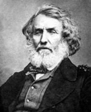
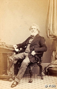
Sir George Everest
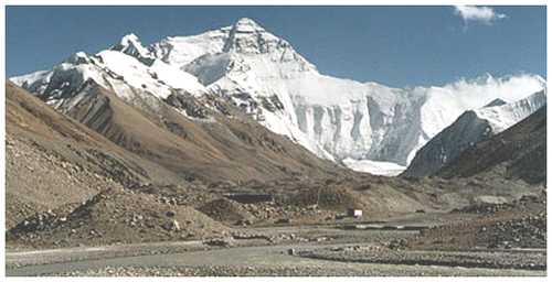
Everest Base Camp at 5500 metres altitude
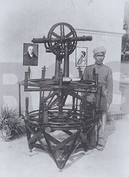
The Great Theodolite
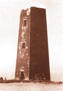
A theodolite towerQuestions
Samantha asked me why people wanted to climb mountains, and I quoted Mallory. I could tell from her look that she didn't believe me. So here's the proof!
"George Herbert Leigh Mallory (18 June 1886 - 8 June/9 June 1924) was an English mountaineer who took part in the first three British expeditions to Mount Everest in the early 1920s. On the third expedition, in June of 1924, Mallory and his climbing partner Andrew Irvine both disappeared somewhere high on the North-East ridge during (or perhaps after completing) the final stage of their attempt to make the first ascent of the world's highest mountain. The pair's last known sighting was only a few hundred metres from the summit. Mallory's ultimate fate was unknown for 75 years, until his body was finally discovered in 1999. Whether or not they reached the summit before they died remains a subject of speculation and continuing research. Mallory is famously said to have replied to the question "why do you want to climb Mt. Everest?" with the retort: "because it is there", which has been called "the most famous four words in mountaineering"".
I don't think some of you were convinced when I told you about all the dead bodies left on Everest, so here's another article:
"A Deadly Tourist Destination.
Everest is the world's most treacherous tourist destination, and its biggest tombstone. It's an environment so hostile that one in 20 climbers die before they ever reach the summit. More than 200 bodies have been left there on the mountain, out in the open, where conditions are so difficult that most corpses have been left where they fell; some are visible from standard climbing routes. Burial takes care of itself. It's not a place to be taken lightly."